
How to Go Fishing Around a Pipe
- Marc Fryt
- Apr 14
- 59 min read
Updated: Jun 21
Let's go fishing around some pipes! Metal pipes, concrete tunnels, and plastic tubes. Pipes that are hidden and pipes that are in plain sight. There could be a lot of pipes where you fish or maybe just a couple. And these pipes might have water pouring out from them all the time or mostly run dry. Regardless of what kind of pipe you find yourself fishing around, they are part of the world we and the fish live in. Pipes are spots for us to go fishing, and the more we learn about them the more we improve both our skill at fishing and our understanding of the places where we fish. So, let's plug our noses, crawl inside some pipes, look around, poke them, see what they do, and observe how the fish interact with them. It's all about casting a line together to see what we can find out!

In this online guide, we're going to do two things. First, we're going to read the water around a pipe — look at the structure itself, how water moves around it, and use those clues to figure out where the fish are and where to make our first cast. Second, we'll look at the water coming out of the pipe: its temperature, its clarity, its foam, its smell. Those properties tell us something about what's in the water and how that might affect the fish. Then we're going to follow the water upstream — crawl into the pipe, so to speak, and see where it leads. Where is this water coming from? What is in the water? And what can knowing that tell us about when and whether to fish around a pipe? That's the quest.
As we wade in together, I will try my best to guide you along and explain things as best as I know them. If you get confused, lost, or broken off, I'm sorry. I am learning how to write about this stuff and explain it in a way that makes sense. And just so you are aware, in the future I may come back to this online guide and re-write certain parts. I may re-write things because I'm constantly exploring and learning myself (this online guide was last update May 2026).
Safety Note- The pipes discussed in this online guide are pieces of infrastructure — they were designed to move water, not to accommodate anglers. Fishing around them carries real risks: unstable banks, slippery concrete, swift and unpredictable flows, and water quality conditions that aren't always visible or obvious. Use good judgment, don't wade in conditions that feel unsafe, and when in doubt, fish from dry land.
That said, if you fish in your city, then you already know that this infrastructure is everywhere. It lines the banks, crosses under the roads, and empties into the waters you're casting a line in. Avoiding it entirely isn't really an option — it's part of what we live in. Learning to read it carefully, and to recognize when conditions warrant stepping back, is simply part of fishing these places well.
Fish smart. And if something doesn't look or smell right, trust that instinct and come back to fish another day.
Additional Note- Although this online guide is written so it can be used by anglers of any experience level, it does build off of my book, The Guide to Urban Fly Fishing. To get the most out of it, and to improve your fishing skills and understanding of local waters, please consider reading it.

What's a Pipe?
A pipe is really simple, right? Water flows into one end of a pipe, passes through it, and then comes out the other end. How much more is there to talk about? What else is worth giving our attention to? Well, for starters, here's something really surprising: Did you know that "pipe" is actually an acronym! — PIPE — Yep, and it stands for:
Place of Intriguing and Peculiar Events
...not really, I'm just joking. But pipes are strange and peculiar, and there's a lot we can learn about them which will improve our fishing skills and understand of the waters we fish. We just need a place to start, and for us that starting point is defining what a pipe is. So, let's come up with a definition for what a pipe is:
In the world of fishing, a pipe is a hollow structure with open ends that allow water to enter, be transported, and then exit from the structure. And a pipe can be made out of all sorts of materials like metal, concrete, plastic, and wood.
That sounds good to me and, even though it is a very broad definition, it helps identify the things that we are fishing around. And below are some examples of pipes that we may find ourselves fishing around:


With that last image, you might be thinking, "That's not a pipe. That's a log!"
Yes, it is a log. But, according to our definition above, it is also a pipe. I included that image of water pouring out from a log to show just how broad our definition is. It is a broad definition because we can find ourselves fishing around pipes that can look very different from one another. But even though they may look very different from one another, they are all functioning in the same way: transporting water. There are, however, pipes that have a special quality different from all the rest, and we'll investigate those unique pipes at the end of the online guide...
Reading the Water Around a Pipe to Locate Fish
Most of the time, we don't know if there are fish around a pipe. The water could be murky and the surface covered with foam making it difficult to see below. In these situations, the way we find out if a fish is around a pipe is by casting a line into the water. But, we want to make that first cast count, because sometimes all you get is one shot to net a really nice fish.
To make the best cast around a pipe, we need to observe how the water moves out and around the structure, because how the water moves influences where the fish might be positioned. In other words, we're going to learn how to "read the water" around a pipe which will give us clues as to where the fish might be located around it.
Locating Fish Around a Pipe That Is Releasing Water Into a Lake
Let's start with a classic fishing scenario: We are fishing along a calm lake and notice a pipe releasing (discharging) water into the lake. As water pours out from the pipe, we watch it mix with the calm lake water creating an area of turbulent water — we see small waves and foam on the surface and the water swirls around in places. We also watch as the turbulent area spreads out and away from shore — the small waves calm down and the foam disappears.

And here's an the overhead view of the lake and the turbulent area formed as water from the pipe mixes with the lake:

Now, let's talk about where to cast your line.
The turbulent area itself is worth fishing. The foam and small surface waves make it harder for birds of prey — eagles, ospreys — to see down into the water, giving fish added security. The water discharging from the pipe may also be carrying nutrients and organic particles that draw smaller organisms like crustaceans, aquatic insects, and small fish toward the pipe. Larger fish follow. Depending on the species and the intensity of the discharge, some fish will hold right in the middle of that turbulent zone — smaller, more agile fish especially. So don't rule out a cast straight into the foam.
That said, larger fish often prefer to sit just outside the most chaotic water, right on the edge of the turbulent area where they can hold without burning extra energy while still being close to the food. The edges of turbulent zones are reliable holding spots. And if there are objects in the water — boulders, sunken debris, aquatic plants, blocks of concrete — those create small pockets of calmer water within or adjacent to the turbulence that are worth targeting too.
So where do you start? First, look at the edge of the turbulent area and see if there are any objects in the water. If there is an object, make your first cast there. If you don't see, or can't see, any objects in the water, then just start casting along the edge of the turbulent area. If you haven't had a hit after casting along the edge of the turbulent area, make your next casts directly into the turbulence.
If you do get a hit, ask yourself this very important question: Why was that fish there? The more you ask that question, look around, and try to piece together an answer, the better angler you'll become.
Lastly, before moving on to the next fishing scenario, I want to add that the tips we just covered can also apply to other "stillwater" situations you may find yourself fishing in, such as calm ponds, a tranquil ocean shoreline, or even a very placid river. In fact, use and apply the tips and information throughout this online guide to whatever pipe you are fishing next to. Use your creativity and curiosity to guide you to the fish.
Locating Fish Around Pipes Discharging Water Into a River
Now, let's say we're fishing along a river — the Missouri River in Kansas City — and we're next to a pipe that looks something like this:

And here's an overhead view of the pipe discharging water into the river:

Take a look at the image above. As the water discharges from the pipe and mixes with the river a turbulent area forms. However, rather than spreading straight out from the pipe the way it would in calm water, the turbulent area gets pulled and bent in the direction the river is moving. As we covered in the previous scenario, that turbulence is worth fishing since agile fish may hold right in it. The pipe might be also discharging nutrients and organic particles which draws smaller aquatic organisms closer in.
But here's what the turbulence adds: a hydraulic shadow (hydraulics is a branch of science that deals with practical applications of liquid in motion). The turbulent zone deflects the river's current and creates a pocket of calmer water immediately downriver. That calmer pocket is protected from the full force of the current, it sits right next to a potential food source, and it's harder for birds of prey to see into the water.
Now add objects into the mix — boulders, concrete blocks, sunken logs or traffic barrels — and the picture gets even more interesting. Any object sitting in or near the turbulent zone will deflect the current around it, creating its own small pocket of calmer water on its downstream side. A fish doesn't have to fight the current, the food is drifting right to it, and it's tucked in behind something solid. In moving water near a pipe, always scan for objects in the water — they could be fish magnets hiding inside an already productive area.
So where do you start? Although I have not personally fished this spot, if I was fishing around that pipe then I would most definitely make my first few casts into the hydraulic shadow just downriver of the turbulence. Then, I would make my next casts by working the edges of the turbulent zone. And I would keep an eye out for any objects in or near the turbulence, and if I saw an objects in the water I would around each one.
Locating Fish Around Wingwalls
The two fishing situations we just covered above involved pipes that were tucked into the shoreline or riverbank. But pipes come in all sorts of shapes and sizes and some pipes, in fact, even have parts that stick out into the water.

At the end of a pipe where it meets a bank or embankment, you'll typically find a headwall — the vertical concrete or masonry face that surrounds the pipe opening and holds the surrounding bank material from collapsing inward. Extending outward from either side of the headwall are the wingwalls — the arms of the structure, reaching out along the bank to stabilize the adjacent slope and guide water toward or away from the pipe opening.
From an angler's perspective, wingwalls are very interesting. Wingwalls extend outward from the sides of a pipe or headwall and into a body of water. Where a wingwall meets the current, it deflects the flow and creates pockets of calmer water on either side. Small fish, insects, and crustaceans get pulled into those calmer pockets — and larger fish are there waiting for them.

The image above shows wingwalls projecting outward from a pipe into the West Fork Trinity River in Fort Worth, Texas. The pipe in the photo isn't discharging water, so the wingwalls themselves are the primary structure holding fish. Notice the two numbered spots on the image.
Spot 1 is on the upstream side of the left wingwall, where the incoming current gets buffered and slowed. Spot 2 is on the downstream side of the same wingwall — another pocket of calmer water where food items carried by the current collect. Both are worth a cast.
If the pipe starts discharging, the fish in Spot 2 will likely get pushed out by the added flow and reposition to Spot 1, which offers better protection from the combined force of the waterway's current and the water discharging from the pipe. When the pipe is discharging, Spot 1 becomes the primary target.
And here is the same pipe and wingwalls but seen from a different perspective:


Locating Fish Around Riprap
Besides headwalls and wingwalls, pipes can also have other common features, such as riprap. Riprap is a term for loose stone, rock, or concrete blocks. Riprap is commonly placed around pipes to prevent soil erosion caused by high-velocity water discharged from a pipe. When water discharges aggressively from a pipe it can tear apart the sediment along the embankment and substrate (substrate is the bottom of a body of water). This erosive force is called scouring, and it can end up damaging the pipe itself. To prevent scouring, engineers and technicians will armor the exit area with riprap to break up and dissipate the energy of the discharging water. A fabric, known as geotextile fabric, is typically laid underneath the riprap to further prevent water from eroding away sediment below the rocks. Below is a photo of riprap and geotextile fabric being installed around a pipe:

The irregular gaps and crevices between riprap stones create countless small pockets of reduced current where small fish, aquatic insects, and crustaceans can hold without burning excessive energy. The most productive zones is where riprap ends and an "unarmored" embankment or substrate begins, such as areas with dirt and plants. This transition zone creates more habitat complexity which supports all sorts of fish and aquatic organisms.
That said, not every pipe gives you a transition zone to work with. Many bodies of water have shorelines and banks lined continuously with riprap, leaving little variation in habitat. Where riprap runs unbroken for long stretches, the pipe itself and its immediate structure might become even more important, because it may be the only meaningful variation in an otherwise homogenous habitat.
Locating Fish Around Plunge Pools
Another feature around many pipes are plunge pools. A plunge pool is a depression that forms in the substrate immediately below a pipe — the direct result of erosive energy scouring away sediment like sand, silt, clay, and small rocks. Riprap is, again, commonly placed in the plunge pool to mitigate scouring and erosion of the substrate.
A plunge pool can be one of the best fish-holding features a pipe creates depending on the flow of water out of the pipe, the depth of the pool, and any objects in the pool. When water flowing out of the pipe is reduced and the pool is at least a few feet deep, you might find fish positioned in it.

Locating Fish Around Aprons
A pipe may also have an apron at the base of the headwall — which is a reinforced surface designed to absorb the erosive energy of discharging water and prevent the structure from being undercut. Aprons are typically made from a large concrete slab, interlocking concrete tiles, fabric formed concrete, or riprap.


The material of the apron matters for fishing. A smooth concrete slab apron offers little holding water for fish — the surface is flat, the current runs fast and unbroken across it, and there's nothing for a fish to tuck behind without burning energy. When the pipe is discharging, fish won't typically sit on a featureless concrete apron itself.
The better target is just beyond where the apron ends. At that transition, the hard substrate (like concrete) gives way to softer substrate (like sand or gravel), the velocity of the water drops, and a small plunge pool often forms as the discharging water scours the unarmored substrate. That deeper, slower pocket is where fish will be holding — close enough to intercept food coming off the apron, but sheltered from the full force of the discharge.

Here's a pretty cool video showing a 3D modeling of water discharging out of a pipe, running across an apron, and then plunging off the apron and impacting softer substrate (like a sandy, silty bottom). As you watch the video, notice how the plunge pool (or scour hole) grows as sediment is picked up and removed from the spot. Below is a screenshot from the video showing the depression formed at the base of the apron:

To mitigate erosion around an apron, engineers will sometimes place baffle blocks (or "energy dissipators") to reduce the velocity of the water. Baffle blocks are typically trapezoidal in shape and made out of concrete. Here's a video showing baffle blocks at work. When water impacts and flows around baffle blocks the area is very turbulent and fish often avoid these places. However, if the water flowing out of a pipe is reduced, then make a cast or two around the baffle blocks to check if any fish are hunkered down around them.

Lastly, aprons can also be made out of riprap instead of concrete. Riprap tells a different story, which we covered above — the gaps and crevices between stones break up the current and can create holding lies directly on the structure. If the apron is riprap rather than smooth concrete, it could be worth fishing if the depth of the water is at least a couple feet deep and not moving too aggressively over the rocks.
Locating Fish Inside of a Pipe
So far in this online guide, we've focused on locating fish around the end of a pipe. In other words, we have been fishing the outlet of a pipe — the exit point where water discharges out from a pipe. But what about locating and catching fish inside a pipe? As ridiculous as fishing inside a pipe sounds, it is possible.
Disclaimer: Do not enter a pipe you cannot see all the way through. Pipes that are dark or blocked from view can fill rapidly and without warning during a storm event. Water levels can rise faster than you can react. No fishing spot is worth that risk. Pipes can also be extremely slippery with debris hidden under the water's surface.

To fish inside a pipe, a few conditions need to line up. There needs to be enough water — typically at least a foot of depth, though sometimes more water means more fish and more options. The flow of water should also be minimal, about the speed of a slow walk. And the pipe needs to be large enough to walk into and make a cast. To be clear, I am not encouraging anyone to crawl into narrow or constricting pipes — if you can't stand or crouch comfortably and move freely, it's not worth it. So, if a pipe meets those conditions then it is potentially a place where you might find a fish.
But before we go any further though, it's worth taking a closer look at what a pipe actually is — because there may be more of them out there than what you realize. To help explain what I mean by this, let's examine our definition of what a pipe is:
In the world of fishing, a pipe is a hollow structure with open ends that allow water to enter, be transported, and then exit from the structure. And a pipe can be made out of all sorts of materials like metal, concrete, plastic, and wood.
If we take a closer look at our definition, in order for an object to qualify as a pipe it must be hollow and have open ends — meaning water can enter at one end and exit at the other. Beyond that, the definition says nothing about a pipe needing to be a specific shape. Pipes can be cylindrical, rectangular, elliptical, or just about anything else so long as they are hollow and passable. The definition also says nothing about length — a pipe could be ten feet or ten miles long and still qualify. And the definition never says the pipe has to have water in it at any given moment. It only says that a pipe has the ability to transport (convey) water from one place to another. The capacity to convey is what matters, not whether water happens to be moving through it at any given moment.
So a lot of objects qualify as pipes under this definition — more than you might expect. Including at least one object that most people wouldn't instinctively call a pipe. Take a look at the photo below:

In the photo above, there are two things worth noticing. On the left is something cylindrical and hollow — no water in it, and by our definition, a pipe. We've already been fishing around its outlet. But let's say we haven't found a fish yet, and we really want to. Squeezing inside that dry pipe isn't going to help. But look at what's in front of us — something large, rectangular, with water in it. Also a pipe, by our definition.
Now, some engineers and stormwater technicians might push back here and say that what's in front of us isn't a pipe at all — it's a culvert. And they wouldn't be wrong. It is more precise to call it a culvert. But under our definition, it also qualifies as a pipe, and that's not just an angler taking liberties with terminology. Even within engineering, a culvert can behave as a pipe depending on conditions — a culvert running partially full of water is technically an open channel, while one filled completely under flood conditions behaves as a pressurized pipe. The hydraulic mechanics behind that distinction are genuinely interesting, and if you want to follow that thread you can explore open channel flow and pipe flow further. Personally, I've already had the enjoyable experience of going down that road (pipe if you will) — far enough to feel confident calling both objects pointed out in the photo above pipes.
For our purposes, the larger pipe in the photo above looks like a place we might find a fish. We can see through to the other opening, and we can see where the water continues on the other side. So let's go in and have a look—
Inside a pipe, fish are responding to the same basic needs they have anywhere else — cover from predators, reduced current to hold in without burning energy, and access to food. The interior of a pipe can, at times, satisfy all three. The overhead enclosure blocks aerial predators entirely, which gives fish a level of security they don't have in open water. Current inside a pipe is typically faster in the center and slower along the walls and floor, so fish will hug the edges and corners rather than holding mid-channel. Any variation in the interior surface — a ridge of corrugated metal, a crack in the concrete, a clump of debris caught against the wall — creates a micro-pocket of reduced velocity that a fish can settle into. In fact, some pipes might have elongated baffles built into the substrate to break up the current and reduce water velocity which provides spots for fish to comfortably swim in. Below is a screenshot from a video of a person walking through a large pipe (often called box culverts by engineers) and in the image we can see examples of rectangular baffles:

In larger pipes (like box culverts), the interior can develop surprisingly better aquatic habitat over time. Algae establishes on rough concrete and corrugated metal surfaces wherever light penetrates, invertebrates colonize the algae, and small fish follow. And then larger fish move in to feed on them when water levels are high enough. Objects in the pipe — woody debris, gravel accumulations, chunks of broken concrete, baffles — function exactly like boulders in a stream, creating hydraulic shadows and holding spots for fish. If you are fishing inside a large pipe, work the edges and corners first, then look for any objects on the floor that are breaking the current. Those are your targets. In lower light conditions inside a pipe, fish may also be less wary than they would be in open water, which can make them more willing to take a fly or lure they might otherwise inspect more carefully.
One more thing worth knowing about large pipes, especially box culverts: they can block fish passage entirely. A pipe that sits too high above the water surface at its outlet, moves water too fast through its interior for fish to swim against, or drops into a plunge pool too deep for fish to jump out of can stop fish from moving upstream through a body of water. For migratory species — like salmon and smallmouth buffalo — a single poorly designed or aging culvert can cut off miles of accessible water. This is an active area of work for fisheries managers and conservation organizations, and it's one of the reasons culvert replacement and fish passage improvement projects matter as much as they do.

When you're fishing a culvert and the water at its outlet seems to hold more fish than the water at the culvert's inlet, that's worth noting — you may be looking at a passage barrier, and the fish have stacked up below it. If you are fishing in a city and notice this, it could be worth sending a letter to your city council and the agency that manages the local fishery (usually that agency is called something like the Department of Fish and Wildlife or Department of Natural Resources). Emails or phone calls such as that can push agencies and local governments to redesign culverts that improve both fish passage and water quality.
Okay, now that we have made it through the pipe, and fishing along the way, let's look at the last spot around a pipe where we could also locate a fish — the inlet.

Locating Fish Around the Inlet of a Pipe
The inlet is where water enters a pipe. For most pipes protruding out of a bank or shoreline, the inlet is somewhere upstream and out of sight, buried beneath soil, concrete, and roadways. But for culverts — especially large box culverts like the ones in the image below — the inlet is right there, visible and fishable, and it creates hydraulic conditions worth understanding.

As water approaches a culvert inlet, it goes through a constriction. A stream or channel that might be twenty feet wide suddenly has to squeeze into an opening that is a fraction of that width. Water accelerates as it funnels into the opening, the same way water speeds up when you partially cover the end of a garden hose. That acceleration does two things of interest to an angler: it scours the substrate at the entrance, and it creates a zone of high velocity that most fish cannot hold in comfortably. Here's a video depicting a 3D modeling of water accelerating through an inlet and scouring the substrate. And below is a screenshot from that video:

The scouring is where it gets productive. As the accelerating water hits the entrance of the culvert, it carves into the substrate — particularly around the base of the wingwalls or headwall where the current is most concentrated and turbulent. Over time these scour holes can become surprisingly deep relative to the rest of the immediate surrounding substrate. During high flow events the holes enlarge. But when the flow drops back down and the velocity inside and around the inlet decreases, those holes become exactly the kind of deeper, slower water that fish seek out — protected from the full current, close to the food being swept toward the pipe opening, and largely overlooked by other anglers who walked right past them on their way to fish the outlet.
Box culverts are particularly good candidates for inlet scour because of their flat headwalls since flat headwalls create sharper flow contractions and more turbulence at the corners — which means more scour, deeper holes, and better holding water. But also keep your eye out for pockets where a wingwall meets the substrate as there is almost certainly a scour hole there worth investigating. Cast into the hole itself when the flow is low enough to allow fish to hold in it, and work the seam between the scoured depression and the accelerating current just upstream of the opening. If there is also any sort of debris, like tree limbs, stacked up against the inlet of a pipe it could add more cover and holding water for fish.

Observing (Reading) the Quality of the Water
Alright, you just fished your way through a pipe, out the other side, and then casted a line around the inlet. You caught a couple fish here and there. You also snagged and lost a lure or some flies on a sunken e-scooter. You re-tie and continue on with your fishing adventure. And, not too much further along, you encounter yet another pipe — a narrow pipe, a hole in the wall, a black abyss pouring water out:

You can't squeeze through this pipe, so you can only fish the water around its outlet. And you already know where you might want to cast your line, because you learned that by observing (reading) the movement of the water around a pipe you can predict where fish might be located. However, what if you could take your fishing skills to the next level? What if you could also observe (read) the quality of the water to further predict if fish might be around any pipe? And what if you could use that skill to also detect what else might be coming out of these pipes? Because you intuitively know it's not just water pouring out from them.
There's no water quality scientist, stormwater technician, or public health inspector beside you. Just you (and maybe a friend or family member), fishing next to the end of a pipe, wondering what stuff is coming out of that pipe, and how that stuff affects both you and the fish. So, where do you start? How do you begin to read the quality of the water around the end of a pipe?
Developing a Baseline
When fishing around the end of a pipe, questions like these might also be popping up into your head: Is water supposed to be coming out of that pipe? Is that smell normal? Should I expect to find a fish around this pipe? As anglers, we ask these kinds of questions because that's part of what it means to go fishing. Our curiosity leads us to ask them, and once they pop into our heads, the search for answers begins. That search starts with something worth reflecting on: the language we use when asking those questions in the first place.
"Normal," "expected," "supposed to be" — these words can mean very different things depending on the pipe, the place, and the person asking. "Normal" for one specific pipe might mean it discharges clear water every day. For another, normal might be a dry concrete apron most days out of the year with the occasional grayish-color discharge. Because normal varies so much from one pipe to the next, it doesn't automatically mean "good" or "bad" — or, for that matter, "natural" or "unnatural." Normal is just a reference point. A baseline. A place to start from.
Whether that baseline represents healthy water is a separate question — and an important one. But you can't begin to answer it until you know what you're comparing against. That's what a baseline gives you.
When you fish around a pipe, you are observing. Through repeated trips — same spots, different seasons, different weather conditions — you develop a baseline for the pipes you fish around regularly. And the more you pay attention, the more useful that baseline becomes. Things shift and change, and you start detecting those variations. If the water around a pipe starts smelling worse than what you're used to, that's telling you something is changing on the other side of that pipe — maybe something worth looking into. If you notice more fish hanging around a particular pipe that rarely holds them — well, first, that's good for your fishing. But it's also telling you that something about the discharge has potentially changed. You may not know what yet. The baseline doesn't give you answers as to what exactly is coming out of that pipe. But it gives you better questions to ask.
The Fish and Other Organisms
The fish themselves are one of the first things to pay attention to — not which species are present, but how they're behaving around the pipe. Are fish grouped near the end of the pipe, even when the hydraulics don't obviously explain why? That could mean the discharge is carrying something attractive — warmth in cold weather, food, dissolved oxygen. Are fish conspicuously absent from a spot that normally holds them? That's worth noting too. A pipe that reliably produces fish on most visits and then suddenly doesn't — with no obvious change in flow or season to explain it — is telling you something changed in the discharge.

Dead fish are the clearest signal of all. A few dead fish near any stretch of water can happen for all sorts of reasons and doesn't necessarily point to the pipe. Many dead fish, especially concentrated near a discharge point or spread across the stretch immediately downstream of it, means something has gone wrong. Note the location, take a dated photo, and report it.
The invertebrates near a pipe tell a slower, more localized story. Because most freshwater aquatic invertebrates — particularly in their larval stages — are relatively sedentary and tied to the substrate, their presence or absence near a specific discharge point reflects conditions at that location more directly than fish distribution does. A diverse mix of mayfly and caddisfly larvae in the substrate around a pipe indicates cleaner, well-oxygenated water — overall better water quality. A stretch near a pipe dominated by chironomids (midges), certain worms, and pollution-tolerant snails suggests impaired conditions — low dissolved oxygen, elevated nutrients, fine sediment accumulation. You don't need to be an entomologist to notice the difference between a diverse insect composition and a midge-only situation. If you're already paying attention to what's in the water and fluttering in the air, you're already collecting this information. You just haven't always pointed it at the water quality question.
Crayfish are worth a specific mention. They're sensitive enough to water quality that their absence in otherwise suitable habitat — rocky substrate, moderate flow, adequate cover — is a signal. If you're fishing a stretch that looks like it should hold crayfish and doesn't, that's worth filing away.


Algae Around the Pipe
Excessive algae growth in or around the end of a pipe — especially the bright green filamentous kind — can indicate elevated nutrients, like phosphorus and nitrogen, in the discharging water. A little algae around the end of a pipe is normal. A thick mat of it concentrated around a pipe is a signal worth noting. When nutrient loading is severe enough, the algae blooms that result can trigger a process called eutrophication — where decomposing algae consumes dissolved oxygen in the water, sometimes dropping it low enough that fish can't survive.


Nutrients like phosphorus and nitrogen, common in fertilizer runoff, sewage, and certain industrial discharges, feed algae growth. Even grass clippings that end up in storm drains can lead to algal blooms around the end of a pipe.

Observing the Plants and pH Levels
If you spot dead or dying vegetation around a pipe it could be an indication that highly acidic water is discharging from the pipe. Highly acidic water discharging from a pipe leaches into the surrounding soil lowering the overall pH leading to the death of plants. Vegetation that is discolored (turning brown or black), dead, or absent in a narrow band around a pipe while otherwise healthy vegetation further away is worth paying attention to. If you are fishing in a freshwater area, pay attention to the aquatic plants, algae, and riparian vegetation (like grass and bushes) along the bank around the pipe. If you are fishing in saltwater or brackish water, look for seagrass, marsh grasses, mangroves (where present), and algae beds.
Plants are sensitive to changes in the pH levels of the water and can show stress or die-off before other indicators become obvious. pH measures the degree to which water is acidic (like lemon juice) or basic (like bleach or soap). pH is measured on a scale that ranges from 0 (strongly acidic) to 14 (strongly basic). In the middle is 7, where the pH is neutral (like in pure water).

If you are interested, pH test strips can help you to make a quick determination of the pH level of the water discharging from a pipe. These pH test strips are simple, low-cost, and lightweight making it easy to pack a few into a water-proof bag or container and pull them out when you want to test the water coming out from a particular pipe.


Water that falls outside a healthy range affects how aquatic organisms function at a basic biological level, damaging gills, fins, exoskeletons, and the ability to reproduce. Fish eggs and juvenile fish are particularly sensitive, and many macroinvertebrates — the small invertebrate organisms that serve as both food source and water quality indicators — are among the first to disappear when pH shifts. Different freshwater species flourish within different ranges of pH, with the optimal pH range for most freshwater aquatic organisms falling between 6.5 to 8. In marine environments, most saltwater organisms require a stable pH between 8 and 9.
Sustained pH outside these optimal ranges for freshwater or saltwater areas can ultimately lead to reduced biological diversity. Additionally, even if a specific fish species can tolerate a more extreme pH, its food source may not. A stretch of water that looks fishable but consistently produces no juvenile fish and has a narrow range of invertebrate species may be telling you something about pH — even if the water looks clean.

If the discharging water from a pipe is low (below a pH of 6.5) it is indicating that acidic material is entering the pipe. As an example, chlorine gas, when dissolved in water, becomes acidic. If someone is draining swimming pool water into a storm drain or there is a broken (or improperly connected) drinking water pipe (from commercial or residential properties) leaking into stormwater pipes then chlorine is being discharged out from that pipe. While chlorine is added to water at levels deemed safe for humans, this chemical is highly toxic to fish and other aquatic organisms. Other sources of low pH can include acid mine waste and leaking landfills.
It is less common to encounter a pipe that is discharging water with a high pH (above a pH of 8) because most of the material that ends up in pipes (from humans) is acidic. But if you do come across discharging water with a high pH, it be coming from a cement manufacturing plant or an industrial landfill.
Sediment
Sediment — fine dirt, silt, and clay particles — coming out of a pipe or accumulating heavily in the water around it can smother plant growth, clog fish gills, and bury the gravelly substrate that invertebrates and spawning fish depend on. Excessive amounts of sediment flowing into a body of water is a process called sedimentation.
In fully built-out urban areas, heavy sediment discharge from a pipe is less common than in developing or recently disturbed watersheds — impervious surfaces like pavement and rooftops actually reduce the amount of exposed soil available to erode. But there are contexts where sediment from pipes is genuinely worth watching for.
Active construction sites are the most significant. Disturbed soil with no vegetative cover erodes dramatically during rain events, and that sediment moves through storm drains and out pipes into receiving waters. If you're fishing near a pipe downstream of an active construction site, sediment loading is a real possibility. Aging infrastructure is another source — deteriorating pipes can allow surrounding soil to erode into the drainage system, and that material eventually discharges somewhere.

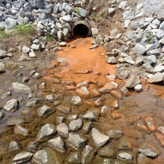



Fine sediment also carries other pollutants with it — sediment particles bind to heavy metals, phosphorus, and pesticides, moving them through the watershed in ways that clean water alone wouldn't. A pipe that looks like it's only discharging muddy water may be delivering a chemical load along with it. And worth noting beyond turbid water: a visible apron of fine sediment fanning out across the streambed around a pipe's outlet — even when the water runs clear — is telling you something about what has been coming out of it over time.
Foam
Not all foam is a problem. Foam that forms from turbulence — water churning over rocks or splashing into a plunge pool — is a normal product of air mixing into water. That kind of foam tends to be tan or off-white, relatively short-lived, and breaks apart quickly as the water calms. It may carry a mild earthy or slightly fishy smell.
The foam worth paying attention to looks and behaves differently — and it comes in two main varieties.
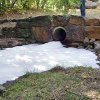
Detergent foam — from laundromats, car washes, or cleaning products entering pipes — tends to be bright white, dense, and persistent. It holds its structure well, accumulates against banks and in eddies, and may carry a sweet, fruity, soapy, or chemical smell. Bright white foam on a dry weather day, with no recent rain and no obvious upstream turbulence, is a signal worth noting.
Sewage foam is less distinctive in color — it can be off-white, grayish, or brownish depending on the concentration and content of the discharge. What distinguishes it is the smell: unmistakably foul, rotten egg, or...like raw sewage. Similar to detergent foam, sewage foam tends to be persistent and accumulate rather than dispersing quickly. This type of foam is frequently a sign that someone (like a plumber or contractor) has improperly hooked up a sanitary sewer line to a separate stormwater pipe. That means raw sewage is bypassing the water treatment facility and is discharging directly into a nearby body of water.
In both cases, avoid contact, and wash your hands and any gear that touched the water before handling food or touching your face.
But trying to identify "good" foam from "bad" foam is difficult at best. Some pipes, like those discharging water from a municipal waste water treatment plant, will be very foamy nearly all the time. Your best bet, if you do encounter questionable foam, is to take a photo, note the location, and email your city's public works or public health department.

Oil Sheen
A thin, iridescent film on the water surface near the end of a pipe — colors shifting from silver to blue to gold — may indicate petroleum hydrocarbons (like gasoline and motor oil) entering the water. It may be accompanied by a fuel smell.
A quick and simple field test can help determine what the oily sheen is: mix the oil sheen with a stick. A petroleum sheen will move as a cohesive film and come back together after you disturb it. A sheen produced by iron-oxidizing bacteria — which is harmless and common in areas with iron-rich sediment — will break apart and crinkle when disturbed and won't come back together. Decomposing leaves can also produce a similar iridescent surface film that breaks up easily. If it smells like a gas station and moves like a cohesive film, it's probably petroleum. If it crinkles and disperses, it's probably not.

Sewage Odor or Unusual Discharge During Dry Weather
This is one of the clearest signals available — but it comes with an important caveat. Not every pipe that has something flowing out of during dry weather is a problem. Some pipes are designed to discharge continuously, carrying treated or partially treated water from a facility as part of their intended operation. If you're fishing near a pipe that always seems to be running regardless of recent rainfall, and the water looks and smells relatively clean, that pipe may simply be doing what it's designed to do.

The signal worth paying attention to is a pipe that doesn't normally run during dry weather — and suddenly is. Particularly if that discharge is cloudy gray, tan, or brownish, and carries a foul smell — sulfur, rotten egg, raw sewage. The spot that normally holds fish is suddenly empty. Trust those observations.
If it hasn't rained in at least 72 hours and a pipe that normally sits dry is flowing, that flow is coming from somewhere it shouldn't. It doesn't always mean something catastrophic — groundwater can infiltrate aging pipes and show up as dry-weather flow — but a change in behavior, especially combined with odor or discoloration, is the most useful single indicator that something may be worth looking into further.
Do not wet wade near an active sewage discharge. Exit the water, wash exposed skin as soon as you can, and note the conditions with a dated photo.
Water Temperature
The simplest tool you can carry is a thermometer. A basic fishing thermometer costs a few dollars and fits in a pocket. Check the temperature of the discharge and compare it to the surrounding water nearby. Even a few degrees of difference tells you something — a warmer discharge in summer may push fish away from the pipe zone, while a warmer discharge in late fall or winter can concentrate them. If you're wading and you feel a noticeable temperature change around your legs near a pipe, that's the same information without the thermometer. Pay attention to it.
Other Field Testing Tools and Tracking Your Data
Beyond a thermometer, if you want to get more specific about what might be in the water around a pipe, there are a few tools and resources worth knowing about — though it's important to understand what they can and can't tell you.
Consumer test strips for water quality parameters like nitrates, pH, chlorine, and copper are widely available and inexpensive. They won't give you laboratory-grade results, and the data they produce isn't the kind regulatory agencies can formally act on. For something like lead, consumer strips have significant reliability problems — research has shown high false negative rates, meaning a strip can tell you no lead is present when it actually is. For heavy metals and contaminants that matter most for human health, certified laboratory testing is the only option that produces results anyone can formally act on. Your local health department or a waterkeeper organization can often point you toward affordable certified testing options.
What test strips can do is help sharpen your observations and give you something specific to say when you make a report. A reading — even an approximate one — tends to get taken more seriously than a general observation alone. The EPA's water quality parameters page and DataStream's water quality guide are good starting points for understanding what a given parameter actually means, where it typically comes from, and what it means for fish and human health.
If you want to go further and connect your observations to a broader community of water monitors, Water Rangers is worth knowing about. It's a Canadian nonprofit that provides citizen-science-grade water quality test kits — conductivity, pH, dissolved oxygen, nitrates, phosphorus, and more — along with a data platform where you can log and share your readings publicly. Water Rangers deliberately focuses on parameters that can be measured reliably in the field by volunteers, which is why you won't find lead or heavy metal kits in their store. Their goal is building a trustworthy, comparable dataset across watersheds — and unreliable data would undermine that. For an angler already paying attention to the water around a pipe, Water Rangers offers a way to formalize those observations and connect them to a network of people doing the same thing elsewhere.
For documenting what you observe in the field, apps like OnWater Fish let you drop pins, add notes, and attach photos directly to a map location while you're on the water. The observation you make standing next to a pipe — the color of the discharge, the foam, the smell, the date and conditions — can be documented in place, tied to a precise GPS coordinate, and saved for later. That kind of dated, location-specific record is far more useful when reporting something to a waterkeeper organization or public agency than a general description after the fact. Drop a pin. Take a photo. Add a note. The habit is simple and the value compounds over time.
A Note on Using AI Tools
As you build your baseline and start asking questions about what you're observing — the color of the water, the foam, the smell, the insects in the drift — AI tools (like Chat GPT, Google's Gemini, and Anthropic's Claude) can be a useful step in understanding what you're seeing. You can take a photo and describe what you are observing and ask for a plain-language explanation. Is this algae or something else? What might cause green filamentous algae to concentrate around a pipe? What does it mean when a stream that normally runs clear is suddenly tan and cloudy after dry weather? AI can help you connect observations to possibilities quickly, and in plain language, without requiring you to already know the vocabulary.
But treat these AI tools as resources to help orient you, not a conclusion. AI tools can be wrong, can oversimplify, and don't know the specific conditions of the specific water body you're fishing. They also can't tell you what's actually in the water — that requires testing, monitoring data, and the kinds of resources we'll get into next.
Think of AI the same way you'd think of a knowledgeable friend who read a lot but has never been to the water you are fishing: useful for orientation, not reliable for diagnosis. Verify what it tells you against the resources and organizations that have ground-level knowledge of your specific waters. Which is, it turns out, exactly where this online guide is heading next.
Further Developing and Using Your Water Quality Knowledge
As you fish around the same pipes over time, you develop a kind of compass — one you can use to know when conditions around a specific pipe are better or worse for fishing. That compass removes some of the guesswork. For example, you might be sitting in your apartment late in the summer, the weather has been dry for weeks, and you know — from experience — that conditions around a specific pipe in town are now better. So you hop on your bike or take the bus, arrive at that pipe, make a few casts, and catch a fish. You just saved yourself hours of wandering around guessing where the fish are.
But beyond improving your skill at catching a fish, you're also gaining unique knowledge on that specific patch of water. With your fishing rod, you notice the small anomalies and slight changes in conditions that a water quality inspector visiting twice a year would likely miss entirely. Data points on a spreadsheet can tell that inspector the chemistry of the water at a specific moment — but they can't capture the history and patterns you've witnessed firsthand. You aren't just watching the water to find a fish. You're developing an intuition for that place that a laboratory simply cannot replicate.
That knowledge also makes you a more effective monitor and advocate for local waters. If something you observe seems seriously wrong compared to what you're used to seeing, you now have crucial information to pass along — to your local department of public health, your department of public works, or a local organization that monitors water quality. In fact, many of the observations we discussed above could be signs of an illicit discharge, which means someone is dumping something into a pipe without having prior permission to do so. A call to your city's 311 service can pull in resources and personnel who might never have known an illicit discharge was occurring. The act of showing up repeatedly, paying attention, and documenting what you see (with photos or videos) is itself a form of sustained local knowledge — and it tends to get taken more seriously than a single anonymous complaint. It marks you as someone who knows, cares for, and understands these waters.






And further still, that same knowledge and experience can also make you a more informed advocate when it comes to infrastructure decisions that affect the waters you fish. Cities and municipalities regularly undertake projects to upgrade aging stormwater systems, replace fish-passage barriers, restore streambanks, and reduce sewer overflows — and these projects often involve public comment periods and community input processes. An angler who has fished the same stretch of water over time, who knows which pipes run dry-weather flow, which culverts block fish passage, and where the habitat has degraded over time, brings something to those conversations that technical reports often can't: firsthand, place-based knowledge accumulated over time.
That kind of knowledge also has a practical dimension that goes beyond individual advocacy. Water quality monitoring is expensive, and most agencies and departments responsible for it are underfunded — testing happens infrequently, and resources are stretched thin across large stretches of water. An angler who can point to a specific location, describe a pattern of change over time, and provide dated photographic documentation isn't just reporting a complaint. They're providing triage — helping agencies direct limited monitoring resources to the places most likely to yield something worth investigating. That's not a small contribution. In a system where not every pipe can be tested and not every water body can be monitored continuously, the person who shows up repeatedly and pays attention is helping decide where the next dollar goes.
The tools and resources below won't replace time on the water — and they won't replace the place-based knowledge you build by showing up repeatedly and paying attention. But they can help you take what you've observed and push it further — to find out what's coming out of that pipe, whether it's been flagged as a problem, and what's known about the health of the water body you're fishing in. Think of them as places to go when curiosity or concern points you in a direction. You don't need to use all of them. You just need to know they're there.
Posted Signs
Look around the pipe for posted signage. Some pipes are required to have signs identifying the pipe, what it is, what it's doing, and who owns it. A sign doesn't mean the water is safe, but it does give you some information to go off of, and maybe a phone number and website if you want to dig for further information. A sign is the simplest possible answer to the question "whose pipe is this and what's coming out of it?" And once you've stood next to a pipe that has a posted sign, you'll start wondering why all the other pipes don't come with informational signs saying what is being discharged and where that discharge is coming from.

Engaging with Departments and Community Organizations
Your observations are useful on their own — but further context makes them more precise. You might notice foam near a pipe and not know whether it's from turbulence or something in the discharge. You might see dry-weather flow and not know if that pipe is supposed to run year-round. Local waterkeeper organizations often have exactly that kind of institutional knowledge, such as which pipes have a history of violations. An angler calling a waterkeeper organization about a specific pipe might learn that other people have also reported similar observations or that the violation has been a known issue for years. That's qualitatively different from what a 311 service can tell you — and it can help transform observations into something people can act on.
Many waterkeeper organizations and local watershed groups also run community monitoring programs — stream sampling, macroinvertebrate surveys, water quality monitoring events — that anglers can participate in directly. Showing up to one of those events, introducing yourself as someone who fishes these waters regularly, and sharing what you've observed over time tends to get taken seriously. The people running those programs are glad to hear from more people who are paying attention, and the relationship that develops from repeated engagement is worth more than any single report.
Online Databases
A few federal databases are worth knowing about. One is the EPA's user-friendly How's My Waterway. Type in your location and it tells you what is known about the health of the water body you're fishing — whether there are known pollution problems, what those problems are, and whether the water has been flagged as unsafe for swimming or eating the fish. Despite the name, "waterway" here means more than just rivers and creeks — the database covers other waters across the U.S. like lakes, bays, harbors, and even many ponds.


How's My Waterway also shows nearby facilities — like factories, businesses, and municipal wastewater treatment plants — that are legally allowed, under the Clean Water Act, to discharge waste into nearby water bodies. In other words, these facilities, or "permitted dischargers", are discharging waste — most likely out of a pipe — into the water where we go fishing. To display these facilities on the map, click "Permitted Dischargers" — yellow diamonds will appear on the map, each one marking a permitted discharger.

The waste that permitted dischargers are releasing into the water where we go fishing is called effluent. Effluent can include chemicals, bacteria, lead, arsenic — things that matter for your health and the health of the fish. If you want to know what's actually in the effluent being discharged, click on a permitted discharger on the map, then click "Facility Report" which will send you over to EPA's Enforcement and Compliance History Online (ECHO).

Once on ECHO, you'll land on a detailed facility report — showing the facility's name, address, permit status, and compliance history. To find records of what is in the effluent being discharged from the facility, click "CWA Effluent Charts" (CWA is an acronym for Clean Water Act).


What you're looking at in those charts is real data — actual reported discharge numbers for specific pollutants from specific pipes. But interpreting what those numbers mean for your health, or the health of the fish, requires a working knowledge of water chemistry, toxicology, and the regulatory limits set for each pollutant. The charts were built to be read by water quality inspectors, environmental engineers, and compliance officers — people who already know what a "GEO limit" is, what "effluent gross" means, and whether a given concentration of E. coli or arsenic in a particular water body is cause for concern or within normal range. For the average citizen standing next to a pipe with a fishing rod, the data is technically public and practically illegible. It's there. But understanding what it's telling you is its own investigation — one that, again, points toward the value of building relationships with the people and organizations who can help translate what the numbers mean for the water you fish.
And there's another frustration. While How's My Waterway and ECHO can tell you the facility doing the discharging and what's in the effluent, they don't pinpoint on the map where the end of the pipe is — they don't tell you the exact place where the effluent is discharging into receiving waters. In other words, neither of these two give you the location of the outfall. There are really only a few ways to make the connection between the facility and the outfall they're discharging from:
The pipe is clearly connected to a nearby facility — a permitted discharger. In other words, you clearly see the pipe, canal, or ditch leading back to the facility, whether in-person or by using satellite imagery.
There is a posted sign next to the outfall with a permit number you can search for directly in ECHO — or a website or phone number where more information is available.
An official, like a water quality inspector or environmental lawyer, is physically next to you pointing out the outfall and confirming its location and associated permit number.
Without using one of those methods to identify the pipe in question, you really have your work cut out if you want to figure out what's in the effluent and where that effluent is coming from (I know, because I tried, and here's just one example of how that plays out). It becomes an extremely time-consuming quest navigating other databases like:
The National Pollutant Discharge Elimination System (NPDES) and learning how to use ECHO through tutorial videos.
Federal, state and city combined sewer overflow (CSO) outfall maps
City geographic information system (GIS) maps showing stormwater drainage networks, pipe locations, and municipal separate storm sewer system (MS4) outfalls.
And navigating those other databases takes understanding what a CSO and MS4 are. ECHO in particular is designed for administrators and water quality professionals rather than for someone doing field investigation from the water's edge. While the EPA knows who is discharging, the exact location of a specific pipe is often buried in the original permit document or a local municipality's internal GIS system — effectively out of reach for the average citizen who just wants to know what's coming out of the pipe they're fishing next to, and what that means for their safety and the health of the fish. When an angler knows exactly what is being discharged into the water where they are fishing — and has the data to back it up — they aren't just fishing; they are also using a practical tool for personal safety and active water quality monitoring.
But instead of throwing our hands up and declaring "the system is broken," that frustration can lead somewhere useful — into deeper questions that investigate the language these databases and regulations use, what those words are actually trying to do, and where their limits are. Questions that can lead to better, more actionable steps we can take as individuals and communities. A desire to find those answers, strangely enough, can be sparked by something as simple as fishing next to a pipe and wondering — why are the fish always around this pipe?
Here is what I've taken away from not only fishing around pipes, but trying to understand what is coming out of them, how that affects me and the fish, and then trying to explain all of that to someone reading an online guide about how to fish around a pipe.
Under regulations like the Clean Water Act, permits, limits, and monitoring requirements have made genuine advances in improving water quality. Before the Clean Water Act, our rivers, creeks, bays, lakes were open sewers. Many of the waters we fish exist in the condition they're in partly because that accountability exists. But the system was built primarily around a single mechanism: enforcing consequences when responsibility is violated. And for identifiable pipes with identifiable owners — that assumption has often held. That is not nothing.
What it hasn't been able to change is everything else — the gaps between what the regulatory system can do and what is actually happening to the water. This is not an argument to "tear it all down." But a regulatory system predominately built around punishment can only do so much. It cannot answer the question a person asks when they fish the same stretch of water twenty times a year: what is actually happening in this water, how is it changing, and is it changing in the right direction? Data about compliance is not the same as understanding whether the water is getting better or worse. The databases don't know the foam is worse on certain days. The permit doesn't know the fish stopped holding near that pipe two summers ago. The compliance schedule doesn't know these are the most mayflies ever seen on this stretch of river. But an angler who fishes the same stretch regularly does. And anglers, collectively, represent something the regulatory system has never had: a distributed, place-based, real-time monitoring network — one that shows up not on a schedule, but out of love for the water. That kind of knowledge comes from attention. And attention comes from our relationship with the things around us like the water, the fish, the insects, and yes — a seemingly simple pipe.
Which is, it turns out, exactly where we need people to be fishing.
Your Turn
You've just covered a lot of ground — from reading the hydraulics around a pipe to find a fish, to learning what the water is telling you about its own health, to navigating the databases and regulations that govern what comes out of the pipes you fish around. That's a long way to travel. And the fact that you're still here says something — most people walk right past these pipes without a second thought. You didn't. That matters.
Whether you've been fishing around pipes for years without quite thinking about them this way, or you're reading this before your first cast around a culvert, the next step is the same: go find a pipe and fish it. Notice where the fish are holding. Notice what the water looks like, smells like, feels like. Build a baseline. Come back. Notice what changes. Ask the questions that pop into your head when you're fishing there — because those questions are worth asking. Not just to help you catch a fish, but for the water. For the people living with these same waters who don't yet know what you now know. And for the fish (and yes, I understand there's irony with saying that).
Take a look at this photo. You'll see it differently than you would have at the start of this article:

That's a pipe attached to an interstate overpass, draining toward the creek below. Roadways like the one in this photo were built — in many cases decades ago — with little to no meaningful input from the communities living alongside the waters it crossed and the neighborhoods it divided. The runoff from that road: motor oil, tire rubber, road salt, 6PPD-Q, whatever accumulates on that pavement from the vehicles passing overhead — drains through that pipe and into that creek.
When that pipe was built, nobody asked the creek. Nobody asked the fish. And in most cases, nobody asked the people who live with these waters either. But there are people asking now. In Seattle for example, anglers are helping to identify pipes where filtration devices can be installed in order to intercept stormwater before it reaches streams. These anglers are turning their knowledge of what comes out of pipes into a direct, physical response to it. That's just one example. There are others, in other cities, around other pipes, on other waters. The form changes. The instinct is the same: notice something, learn about it, and find a way to act on it.

Those filtration devices aren't a final answer. They're a step — a better direction while the deeper questions are still being worked out. Questions about the road itself, the cars on it, the tires wearing down against the pavement, why we're driving, where we're going, what's being moved and why. The relationship between a community and its water doesn't end at the pipe. It runs all the way back up the watershed, back up the road, back to decisions that were made — and decisions that are still being made.
Relationship changes direction. It's about fishing around a pipe, being aware of it, learning about it, reporting it, asking better questions about it, and finding better answers — and then, when you find a partial answer, asking what's still missing. The filtration device is one step. The report to the waterkeeper is one step. Showing up to a public comment meeting is one step. Each one changes the relationship a little, and the relationship is what changes everything else. Not all at once. Not easily. But there — at the end of a pipe, with a fishing rod in your hand, asking what's in the water, and willing to follow that question wherever it goes.
Go fishing.
Who Owns This Pipe? And What's Coming Out of It?
While writing this online guide I found myself pulling up maps of other cities, looking for pipes that caught my eye — pipes I'd want to cast a line around if I were there. It was a way of testing the ideas in this online guide against places I'd never fished, asking: "If I were standing next to this pipe, where would I look for fish? How would I read the movement of the water? Where would I cast my line?"
One of those map searches took me to this pipe in Kansas City, along the Missouri River. And as you are already aware, it is a pipe that we looked at earlier in this online guide:
Beyond imaging myself fishing around that pipe, I also was curious to know:
How clean (or not clean) is the water coming out of that pipe? And where is that water coming from?
Those two questions — questions that should have straightforward answers — tangled me up for hours. This is where you come in. Maybe you could help me out by looking through how I investigated this pipe. Maybe you might spot something I missed.
Let's go explore this pipe together.

Besides easily spotting the water discharging from the pipe, what's also interesting is looking at the pipe through historical satellite images on Google Earth. Scrolling through the historical imagery, this pipe has been actively discharging over decades:


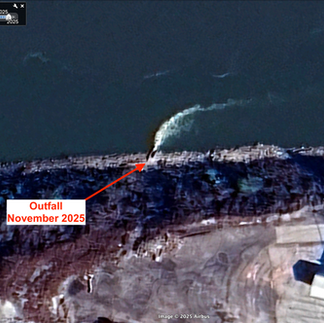
The next stop I took was the federal EPA's combined sewer overflow (CSO) outfall map — a logical starting point, but the pipe wasn't there, because it likely isn't a combined sewer overflow point. Strike one. (And honestly it would surprise me more if it was a CSO outfall due to the amount of water it discharges over the years).

Next was EPA ECHO, searching by facility name and location. Looking on Google Maps and How's My Waterway, there is a large wastewater treatment plant (WWTP) just south of the pipe — the Westside Wastewater Treatment Plant. So I decided to try this facility first. Two facilities came up for "Kansas City Westside," but both records were nearly empty — no Clean Water Act data, no outfall information, no permit links. Strike two.

Next, I did an internet search for an environmental agency in Missouri and came across the Missouri Department of Natural Resources. Then I navigated over to the Missouri DNR's permit database to check for permits filed for the Kansas City Westside Treatment Plant. That database was more productive — it confirmed the Westside WWTP owns a different outfall slightly downriver, which at least ruled out the pipe I was interested in is not owned by the Westside WWTP.
Okay, so the next question was figuring out who else could own this pipe. Nearby, just across the Kansas-Missouri state line is the Kaw Point WWTP. But searching for "Kaw Point" in Missouri's permit database returned nothing, because the facility, despite the pipe discharging into the Missouri River on the Missouri side, is physically located in Kansas and most likely permitted under Kansas law.
That led me to the Kansas Department of Health and Environment (KDHE) — Kansas's permitting authority — but I was unable to easily locate an intuitive public permit search tool. I did find a "Wastewater & Stormwater Permitting & Compliance" webpage but, again, I wasn't able to locate a permit/outfall search tool. On that page, there was a "Wastewater Permitting & Compliance Directory" which was just staff phone list, not a database. And the Municipal Programs section just dead ended to some fiscal documents, financial audits, and water quality memorandums.
Back on ECHO, searching "Kaw Point" in the "Facility Name" search bar finally surfaced the right facility — Kansas City Plant No. 1 WWTP (Kaw Point), federal permit KS0038563 under the Clean Water Act. (To even know that's the right permit number requires knowing that ECHO tracks facilities across multiple regulatory programs simultaneously, and that the same "Identifier" column holds permit numbers from completely different statutes. That's not obvious.)
With a permit number in hand, the National Pollutant Discharge Elimination System website is worth checking — it sometimes contains permit documents with outfall coordinates. But searching the federal permit number KS0038563 in NPDES turned up empty.

The actual permit document — the one that would have a site map and an outfall table with precise coordinates — lives somewhere in KDHE's internal system (I think), accessible by calling or emailing a staff person whose name appears in a PDF directory (maybe).
I even reviewed this large document which talks about the facility but, again, doesn't say exactly where the primary outfall is located. Same permit number: Federal Permit No. KS0038563
Total time: over two hours. Confirmed answers: None. I could not definitively determine who owned the pipe I am interested in — and without that, I couldn't find out what's coming out of it. The work of identifying a pipe, finding its permit, understanding what's in the discharge, and knowing who to call — that is work the permits, the databases, and the maps should already be making easier.
The lesson: All of this information is technically public. The Clean Water Act requires it to be. But "public" and "accessible" are not the same thing. The data is distributed across federal and state systems that don't talk to each other cleanly, split along state lines that mean nothing to a river, buried in archived PDFs, and ultimately gated behind staff contacts who hold the actual documents.
I have never personally fished around this pipe, so there could very well be a posted sign that gives a permit number and a website or phone number for further information. But then getting to that sign would depend on if trespassing laws prohibit access (as the average citizens doesn't own a boat or wouldn't approach a facility manager to ask for site access).
This pipe remains a "black box" for the average citizen — difficult to pry open and see what's going on inside. And relying on the fact that Kaw Point is a major treatment facility near that outfall, but without a site map from the physical permit document, that is an educated guess rather than a verified fact. The transparency the law promises exists on paper. At the water's edge, it dissolves.
The tools do exist — ECHO, How's My Waterway, federal and state permit databases — and they're worth learning. But they have real limits, and those limits aren't evenly distributed. A large pipe on a navigable river in a major metro area, operated by a large public utility, should be among the easiest cases. If this one takes over two hours and still lands on "probably this facility," what does that mean for the thousands of other pipes out there?
You can't beat yourself up for not being able to track down these answers. Even water quality investigators have a difficult time tracing where pipes go and where contamination is coming from. In fact, there are cases when investigators resort to pouring colorful fluorescent dyes or pumping smoke into drains and manholes to determine where effluent flows and which outfall eventually discharges it. That, to me, seems crazy. We have a massive network of pipes under our feet that should be mapped and easily accessible to the public — and yet professionals are out there pouring dyes into manholes to trace them. Nothing about that is "publicly accessible information."
Before leaving this pipe, I do have recommendations on trying to find the answers to who owns that Kansas City pipe and figuring out what is coming out of it. If you do want to find the answers of who owns this pipe and what comes out of it, you could continue the search by:
Emailing or calling KDHE directly. You have the staff directory. One email or call to the Municipal Permitting section asking for the permit document for KS0038563 and specifically the outfall coordinates table will likely get you an answer within a day or two. It shouldn't require this, but it could work.
Looking at the pipe itself. Permitted outfalls are often required to be marked — a stenciled outfall ID, a posted sign, or an agency marker. If you're around the pipe, a closer look at the pipe structure or the bank around it may tell you more than an hour of database work. (Though I'm not personally familiar with Missouri or Kansas water access laws, so the pipe could potentially only be approachable by boat or with prior written permission to avoid trespassing.)
Calling KC Water and the Unified Government of Wyandotte County. Both are public utilities with public information offices. "I'm someone who fishes the Missouri River near Kaw Point — can you tell me if this outfall is yours?" is a reasonable question they're obligated to answer.
If you do find any answers, I'd love to know what you find out and include it in this online guide here.
Outfall — The Weight of a Word
While trying to write this online guide, I kept running into the same wall: the information exists, but it's organized around a language most anglers have never needed to learn. A language of permits, identifiers, regulatory designations. And within that language is one word that keeps appearing — on maps, in databases, in permit documents — doing more work than it looks like it's doing. In fact, it's a word I've been using in this online guide. It's a word you have already read again and again. And it's a word worth looking at more closely.
That word is outfall.
Most of the pipes we've been fishing around in this online guide have more in common than we might expect. They share similar hydraulics — the way water accelerates out of them, scours the bottom, creates that plunge pool or hydraulic shadow where the fish hold. They carry similar questions about what's in the water — the foam, the oily sheen, the dry-weather flow that shouldn't be there. But many of them also share something else, something less visible: a word. A legal identifier. Many of these pipes — probably more than we'd expect — are outfalls. Not just pipes. Not just discharge points. But also designated, permitted structures with a legal identity, an owner, and a set of conditions governing what can flow through them and into the water we're casting a line in.

That matters. Because it means the water coming out of those pipes isn't entirely ungoverned. There is a system — a framework of permits, monitoring requirements, and legal obligations — that is supposed to tell you what's in that water, who is responsible for it, and whether it meets the standards set for the water body it's entering. That system is theoretically transparent. The information is theoretically public. But through this online guide we have found that it isn't designed for the average citizen doing a field investigation.
That's why the language matters. Because understanding even a little of the language can help you ask better questions and know when something you're observing at the water's edge is worth pushing on.
The word we are going to explore is outfall. Here is what it means — and what it's actually doing.
Nine Words
The federal Environmental Protection Agency (EPA) has more than one definition of outfall across its different programs and glossaries.

One of those definitions is broader — "the point where water flows from a conduit, stream, or drain" — which could describe almost any pipe or conduit emptying into anything. But the definition most directly tied to the permitting system that governs what we've been talking about — the one that carries the regulatory weight — is this one:
Outfall — the place where effluent is discharged into receiving waters.
Nine words. That's the definition we're going to look at closely, because those nine words are doing the most work. Let's follow our curiosity and crawl inside that definition, take apart those words, and see where it leads. (For a note on the definition of outfall used in this article, see here.)
"Effluent"
Let's start with effluent since it immediately jumps out as an unfamiliar word. What does effluent mean? As far as I have been able to piece it together, after searching various EPA regulations and guidelines, "effluent" broadly means water and waste. The word "waste" itself isn't defined in the NPDES regulations either — but under federal environmental law more broadly, waste has been defined to include almost anything discarded, abandoned, or destined for disposal, including plain dirt.
By leaving it undefined and broad, the EPA ensures that anything coming out of that pipe could be under their watch. A large volume of pure water with a microscopic trace of sediment technically qualifies as effluent. So does highly toxic amounts of lead mixed with a little bit of water. Effluent could be something safe to drink gallons of, or it could be something life-threateningly toxic — and the definition of an outfall doesn't distinguish between the two. The word effluent itself tells you nothing about what you're fishing in.
For the public, this distinction is a warning: A "permitted outfall" does not mean "clean water." A pipe can be legally discharging "effluent" that meets its permit requirements but is still not something you’d want to swim in. The term "effluent" is a neutral mask for a wide range of potential hazards. While the word "effluent" is a blank slate, the NPDES permit attached to a specific outfall is the decoder ring. It is the only document that actually lists the specific chemicals, temperatures, and volumes allowed to pass through that point. Without that permit in hand, an observer has no way of knowing if the "water" they see is life-sustaining or life-threatening.
While the definition of outfall doesn't tell us what's in the effluent is being discharged, but it does tell us where that effluent is being discharged.
"Into receiving waters"
Receiving waters sounds like what it would mean to most people: a natural river or lake — the environment. And some EPA definitions point in that direction: a river, lake, ocean, stream, or wetland. But other EPA definitions say something different. Depending on which EPA document or program you're reading, receiving waters can include both what some would call natural systems and man-made ones. A concrete flood control channel can qualify. A constructed recreational lake fed by treated wastewater can qualify. A human-made drainage ditch can qualify. (For a further look into the definition of receiving waters, and waters of the United States, see here.)


In the photos above, one image is a concrete pipe in a wooded landscape, the other image is a tunnel along a concrete river. While these two photos look drastically different from one another, they share a common thread. They are "where effluent is discharged into receiving waters."
For us, as anglers, the simplest interpretation is that "receiving waters" means "where we go fishing."
There's also something worth noticing in that word "receiving" — it positions the water as the passive party in this relationship, the thing that accepts what the permitted system sends its way. It only receives. It doesn't push back. But that could just be how I am interpreting that part of the definition rather than the word's inherent meaning.
"The place"
We just dissected effluent and receiving waters to mean "water and waste being released into where we go fishing." But what about the last part of the definition we have yet to look at. What is meant by "the place"? Where is "the place"?
The EPA doesn't define "the place" as a standalone term either. Here, again, I have to sift through EPA regulations, guidelines, and the National Pollutant Discharge Elimination System to figure out what "the place" means. And through my digging around, "the place", turns out, is actually a multi-step process:
Someone or some entity has some waste that they would like to get rid of.
That entity files paperwork with an environmental agency (usually a state agency) to receive a permit to discharge their waste.
The entity with the waste and the environmental agency agree on a place for where that waste is to be discharged. In other words, they designate, they decide on where "the place" is.


But here is where things get even more interesting. "The place" doesn't have to be the end of a concrete pipe or tunnel. "The place" can be, in fact, lots of things. It can be the end of a canal. It can be where a creek flows into a river, or even where a river flows into the ocean. It doesn't matter at all what "the place" looks like, whether it's made out of plastic or organically grown wood. All that matters is that "the place" is approved of by an environmental agency.
Take a look at this screenshot from an MS4 outfall inspection training video (at about 17 minutes in):

In the screenshot, the inspector in the hi-vis safety vest is pointing to a legitimate outfall. It is not the end of a pipe. It is not the end of a tunnel. It does not look like anything we've been fishing around during this entire online guide. And yet that exact place — those tall blades of green grass next to a small pool of calm water — is, legally speaking, an outfall. It is "the place" where effluent is discharged into receiving waters.
An outfall only truly exists in paperwork, on maps, in coordinates, in waste limits and monitoring requirements, on posted signs, within a permit number, throughout state and federal environmental regulations, and when an inspector points it out to us. The act of designation — of deciding where waste is to be discharged — is what creates an outfall. We only know an outfall exists if we have access to the information — maps showing outfall locations beyond just CSO or MS4 outfalls, searchable permit databases that include coordinates, plain-language information about what's in the effluent, and what that means for human and fish health. Without that, the vast majority of outfalls remain effectively invisible and unknown to the average citizen. With that information, anglers can become better monitors and educators of the waters they fish. Transparency is the bridge that turns a bystander into a steward.
Drawing a Line
Here is the original definition of outfall that we started with:
The place where effluent is discharged into receiving waters.
After crawling into that definition, here is the definition we have ended up with:
An exact location on a map, within legal paperwork, or pointed out by an inspector where some entity, assigned responsibility, can release anything permitted into the waters where we go fishing.
At the outfall, a line is drawn. But that line isn't created by the pipe, the water, or the fish, but by paperwork and legal definitions. On one side of that line, a specific person, company, or entity is responsible for what’s in the effluent As effluent flows past this line, the law redefines it: "effluent" becomes "receiving water." Suddenly, the effluent, the waste, belongs to everyone, which—in the real world—usually means it belongs to no one.
The regulatory system uses these sharp lines to assign blame and collect fees. But the fertilizer, the motor oil, the 6PPD, the PFAS don't feel themselves crossing a legal threshold — they simply continue their trajectory. They are tied together: the limits in a permit decide what kinds of "waste" and how much of it is allowed to discharge from an outfall, but when that "waste" builds up and causes damage, the law is eventually forced to change its rules. The "waste" and the laws are constantly pushing back and forth on each other. But as the back-and-forth continues, the "waste" accumulates.
This regulatory line isn't a fiction; it is a sturdy construction written into maps, stored in water quality databases, permit documents, and carried on the clipboards of inspectors. It has been a vital tool for improving water quality, but it has its limits—and it is a category that does not fully describe the reality of what is really happening at the water. A fish doesn't know it lives in a "natural creek" receiving "effluent" from a "permitted system." To the fish, there is no "inside" or "outside"—there is only the continuous flow of the water from a pipe and into its body. And once you realize a line is trying to be drawn, trying to be stabilized, you can never look at the end of a pipe the same way again. It's a place where we stop looking at a pipe as a simple thing and start seeing it as a massive, swirling network of humans and non-humans — where we see the "social" world and the "natural" world have been one and the same all along. It's where enforcement sets limits, but relationship changes direction.
If we see the water in the pipe as already being "the river" or "the bay," the motivation shifts from meeting a permit to protecting a neighbor.
A note on the definition of "outfall:" The definition of outfall in this article — "the place where effluent is discharged into receiving waters" — comes from the EPA's Terminology Services glossary, which carries a disclaimer noting that its definitions are not official regulatory language. Searching for an authoritative definition in the actual regulatory text — specifically 40 Code of Federal Regulations (CFR) 122.2, the definitions section of the NPDES permit program regulations — turns up nothing. The word outfall does not appear there as a defined term. In other sections of 40 CFR Part 122, it is defined narrowly and contextually — in the stormwater section, for example as a point source where a municipal separate storm sewer discharges to waters of the United States. No single, stable, official definition exists across the regulatory framework as a whole. For a word that determines where legal accountability ends and where the receiving water begins, that absence is worth noting.
This creates a system where the "line of accountability" is defined by a term that the EPA's own disclaimer says is not "official regulatory language." It essentially forces a facility to comply with an "outfall" requirement that, by a strict reading of the CFR, only legally applies to a municipal storm sewer.
Lastly, the NPDES program regulates "point sources" — the pipes, ditches, and conveyances doing the discharging. Every outfall is a point source, but not every point source is an outfall. A pipe discharging to another part of the same facility is a point source but not an outfall. The two terms are never formally defined in relation to each other in the regulations. So the angler trying to trace a pipe back to its permit is navigating a vocabulary that the regulations themselves haven't fully connected.
To summarize my point here, while a strict literalist reading of the CFR suggests an outfall only applies to municipal storm sewers, the legal system bridges this gap through individual permit integration. When a facility is granted an NPDES permit, the EPA or state agency legally establishes precise geographical coordinates for designated internal points—explicitly labeling them "Outfall 001," "Outfall 002," etc.—directly in the binding permit text. Consequently, the facility is held accountable to the specific terms of its unique permit rather than a universal statutory definition. However, an "external citizen" or angler trying to trace a physical pipe back to a broader statutory framework faces a disconnected vocabulary making such water quality data beyond reasonably accessible to the average citizen.
A note on "receiving waters" and "waters of the United States": These two terms sound like they should mean the same thing — the water body on the other side of the outfall, the place where the fish live, the place where we go fishing. But they are not the same thing, and they are never formally linked in the regulatory text as far as my investigation has ventured. "Receiving waters" appears throughout EPA glossaries and permit documents but is never defined in 40 CFR 122.2, the main definitions section of the NPDES permit program. "Waters of the United States" — the term that triggers Clean Water Act jurisdiction and protection — is defined separately in 40 CFR Part 120.2, a different section of the CFR entirely, and that definition has itself been contested, revised, and partially narrowed by the Supreme Court's 2023 Sackett v. EPA decision. An outfall is formally defined as discharging to "waters of the United States" only in the stormwater section of the regulations — not as a general principle across the permit program. What this means in practice is that three terms doing enormous regulatory work in the same system — outfall, receiving waters, and waters of the United States — are never formally defined in relation to each other. The line the outfall draws is far less precise than the framework implies.